For More Information On The Locations Of This Movie Plus Some Great Pictures On How Some Of The Locations Look Today Check Out This Site Here
- (0:03) Jeff And Amy Taylor Stopping At A Gas Station And Encounters Trouble Maker Earl / Archview Resort; Just North Of Where Highway 191 And Highway 313 Meet, Moab, Utah (Note: This Place Is Located On The East Side Of The Road)


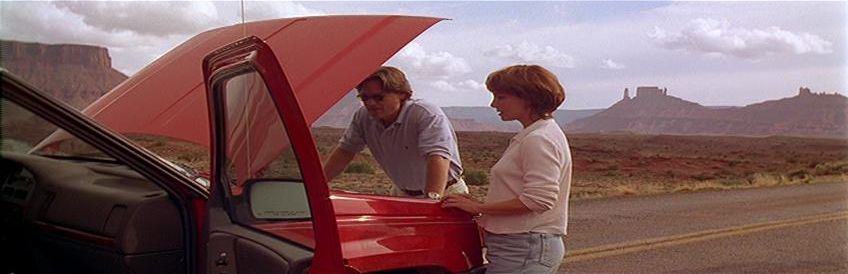
- (0:09) Spot Where The Taylor's Vehicle Breaks Down / Highway 128, Castle Valley, Utah (Note: They Were Traveling South When The Car Broke Down)


- (0:15) Jeff Showing Up At Belle's Diner / 40020 240th Street E, Lancaster (Note: This Building Is Totally Vacant And On The East Side Of The Road. Also, I Hope The Pictures From Inside The Building Wont Offend Anyone As Vandals Have Written On The Walls)


- (0:17) Jeff Driving And Taking A Sharp Left Turn / Ivanpah Road And Morning Star Mine Road, Nipton, CA (Note: He Was Heading North On Ivanpah As He Made A Turn To The West)

- (0:18) Spot Where Jeff Gets The Trucker To Pull Over / Ivanpah Road, Nipton, CA (Note: He Is Heading South Which Is The Opposite Direction Of The Way He Was Coming In The Prior Scene)


- (0:35) All Of The River Scenes / Auburn, CA

- (0:43) View Of The Town / Sloan, Nevada (Note: The Town Is Fake And Not Really There. This Location Is Just Off Of Southern Nevada Lightweight Road. The View Is Looking Southwest)

- (0:44) Jeff Making It To The Town That Has The Bank / 7th Street And C Street, Victorville (Note: The Camera Is Looking Northeast Down 7th Street)


- (0:45) The Bank / 15561 7th Street, Victorville (Note: This Area Of Town Is Unfortunately Starting To Get A Little Bit Run Down As You Can See From My Pictures)


- (0:50) Jeff Goes To the Phone Booth To Receive His Call / Northeast Corner Of 7th Street And B Street, Victorville


- (0:51) Jeff Getting Picked Up By The Railroad Crossing / Nipton Road Near Nipton Moore Road, Nipton (Note: He Is Walking West As He Gets To The Railroad Crossing)

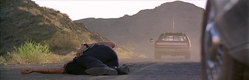
- (0:57) Where The Officer Was Shot And Where Jeff Kills Earl / Highway 165 Just East Of Highway 95, Nelson, Nevada (Note: This Is About Three Miles East Of Nelson And About Five Miles West Of Where The Road Runs Out At The Colorado River. The View In The First Screen Shot Is Looking East)


- (1:00) The Truck Stop / Lenwood Road And Commerce Parkway, Barstow


- (1:05) The House And Barn / West Potrero Road, Westlake Village (Note: This Is Set Way Off The Road And Is A Private Ranch So Respect The Owners And Don't Try To Go Up To The Barn)

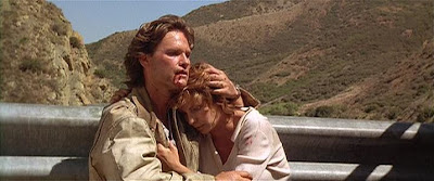
- (1:24) The Big Bridge / Golden State Highway Just North Of Where Cherry Canyon Road Intersects, Los Angeles County (Note: This Location Is Very Hard To Describe On Where It Is. You Go North Up From Los Angeles On The I-5 Freeway And Go Through The San Fernado Valley Valley And Past Santa Clarite/Valencia And Exit At Templin Highway To Reach The Golden State Highway. About One Mile From The Bridge The Road Will End And You Have To Walk The Rest Of The Way)


Very nice info for a Breakdown fan like me.
ReplyDeleteOne question: When J.T Walsh points at the town, where Kurt is heading for the bank, is this also in Victorville? I mean at the mountain just after the river scene.
Where exactly is this location?
Thanks.
yes it's victorville brackett bank boarded up now
DeleteEDITED:
DeleteWhen Red/Warren shows Jeff the town of Brackett, a 'two-bit shit hole in the middle of nowhere', the town, from the perspective of that scene atop the hill, is actually CGI'd in, and a completely different town(Victorville) is used for the County Bank and other close-up street scenes.
Loved this movie! Thanks for the post! :)
ReplyDeleteam deperate to find out the name of the country tune playing on the jukebox as Jeff enters Belle's Diner... Please help.
ReplyDeleteveracarn1@yahoo.com
Game of Love - NOT available for purchase. I tried to Shazam it but nothing came up. Was produced specifically for this movie. OTOH: When Kurt Russell returns to the diner, "Burgers & Fries" by Charley Pride is playing over the jukebox. This movie is excellently paced and I never grow tired of watching it! The characters are so ordinary(both the good guys and the suitcases!) as to be completely credible. Good job J. Mostow!
ReplyDeleteThank you... that is the title I came up with as well but have been unable to locate it... I rushed to assume that I was way off base... I have the vocalist as Robbyn Kirmsee. And though some of her stuff is featured on youtube, this particular song is not. Thanks again
ReplyDeleteJust saw the farm house on a Viagra commercial. It's the commercial where the cowboy uses horses to pull his truck out of the mud. Barn looks nicer nowadays. 100% the same house and barn.
ReplyDeleteThanks I will have to look for that commercial. Too bad it is private property as I may never get there to take pictures.
Deletehttp://okaynowiamconfused.blogspot.com/2011/05/erectile-dysfunction-hold-your-horses.html
ReplyDeleteSame house, right?
The actual commercial has great views of the hills behind the house.
Yes it is the same farm. Everything looks better now as compared to the movie!!
DeleteAfter spending an hour on the net, I found the bridge. Use Bing maps instead of Google maps. In Bing maps, paste these coordinates in the search box. --> 34.639899, -118.760936 and use the bird's eye, zoom-in and rotate features to see this bridge from 4 angles. COOL! I double checked the images with still frames from the film.
ReplyDeleteAll the action seems to take place on the south side of the bridge. They drove in from the southwest road. It's actually the very end of "Golden State Hwy" before it ends in a little turn circle loop. All this is just a tiny bit south of Pyramid Lake and Pyramid Dam in California.
Hi Chas - It's MrLocation. Thanks for putting a link at the top of your Breakdown page for my Webshots pictures. I moved them to Flickr as Webshots was changing and I didn't like the new site. Can you change the link to: http://www.flickr.com/photos/mrlocation/sets/72157632018133624/ Thanks! I'm doing Route 66 from 29th June and am going to look for that illusive overview of 'Brackett' again near Barstow, but I'm getting think it is more likely to be in the Nevada desert. I think an aerial shot of Victorville was cropped and used to create a matte scene in the desert. What do you think? john.de-kisshazy@btconnect.com
ReplyDeleteHi MrLocation,
DeleteIt would be awesome if you find this "Brackett" location. I have tried google Earth,etc, but no luck :/ Good luck for the search of the location. I really hope you find it.
roymoe493@hotmail.com
Hi Chas! Thank you for your magnificent work! I am reading your blog at the same time as I'm watching Breakdown. I came across your blog cos I was wondering where the town of Brackett may be...
ReplyDeleteRegarding the highway where Earl is shot dead I believe is the Laughlin highway, or Hwy 163 at the southern tip of Nevada. The blog says CA 165 but that sounds not right...Go to Nevada 163 and you will see it is east of a hwy 95 just like the blog says... looks identical, but they have since paved it to 4 lanes in some spots.
ReplyDeleteHello, thanks for the message. I did make a mistake as I put California as it is Nevada but I do have the correct roads listed. Go back and look at my updated post and I described it a little better and you can find the exact spot on Google Street View now.
DeleteChas,
DeleteDid you ever find out the name of the town in frame 43?
The view of 'Brackett' was taken facing SW from the area at 35.829823, -115.225949 (just off Southern Nevada Liteweight Road).
ReplyDeleteA town doesn't exist there so it would have been a matte painting combined with the road below, as MrLocation points out.
Wikipedia article of the film states filming location also in Tasmania. Seems like a waste of budget to fly everyone there and is probably incorrect anyway because all scenes are described here.
ReplyDeleteThe Bridge is impossible to find on Google Maps with the info provide here. Any additional bits of info?
ReplyDeleteOk, it's 34.63999609749702, -118.76094072883566 thanks to one comment-poster above !
DeleteIt's Piru Gorge, by the way.
DeleteWow.. didn’t know the river scene was filmed in Auburn, ca… I live in the next town 😊 this is one of my favorite movies.
ReplyDelete